<!DOCTYPE html>
<html lang="en">
	<head>
		<meta charset="utf-8">
		<meta http-equiv="X-UA-Compatible" content="IE=edge"/>
		<meta name="viewport" content="width=device-width, initial-scale=1, maximum-scale=1.0">
		<meta name="format-detection" content="telephone=no">
		<title>Icomos Türkiye</title>
		<link href="favicon.ico" rel="icon">
		<link href="assets/bootstrap/css/bootstrap.min.css" rel="stylesheet">
		<link href="https://fonts.googleapis.com/css?family=Playfair+Display:400,400i,700,700i&amp;subset=latin-ext" rel="stylesheet">
		<link href="assets/style.css?ver=1" rel="stylesheet">
		<!--[if lt IE 9]>
		  <script src="https://oss.maxcdn.com/html5shiv/3.7.3/html5shiv.min.js"></script>
		  <script src="https://oss.maxcdn.com/respond/1.4.2/respond.min.js"></script>
		<![endif]-->
		<script src="https://ajax.googleapis.com/ajax/libs/jquery/1.12.4/jquery.min.js"></script>
		<script src="assets/bootstrap/js/bootstrap.min.js"></script>
		<script>
			$(document).ready(function() {
				
				$(document).on("click",".languageBar a",function() {
					var path = window.location.href;
					var targetLanguage = $(this).text().toLowerCase();

					if(typeof path === "string" && path.indexOf("?Sayfa") > -1 && path.indexOf("&dil") > -1){
						window.location = path.split("&dil=")[0] + '&dil=' + targetLanguage;
					}
					else{
						window.location = path + '?Sayfa=AnaSayfa&dil=' + targetLanguage;
					}
				});
				
				$(document).on("click",".icomosSearch div",function() {
					if($("#icomosSearch").val() != ""){
						window.location="?Sayfa=IcerikAra&s_ara="+ $("#icomosSearch").val() +"&dil=en";
					}
				});
 
				$('.icomosSearch input').keyup(function(e){
					if(e.keyCode == 13 && $("#icomosSearch").val() != "")
					{
						window.location="?Sayfa=IcerikAra&s_ara="+ $("#icomosSearch").val() +"&dil=en";
					}
				});
 
				$(document).on("click","a.dropdownMobilMenu",function() {
					$(this).next().fadeToggle();
				});
				
				if ($(".subMobileMenuList a.active").length == 1){
					$(".subMobileMenuList a.active").parent().show();
				}		
			});
			function openNav() {
				$("#icomosSidenavId").fadeIn();
			}

			function closeNav() {
				$("#icomosSidenavId").fadeOut();
			}
		</script>
	</head>
	<body>
	<div id="icomosSidenavId" class="icomosSidenav">
		<a href="javascript:void(0)" class="closebtn" onclick="closeNav()">&times;</a>
		<a href="javascript:void(0);" class="dropdownMobilMenu" data-icomos-active="">ABOUT</a>
			<div class="subMobileMenuList">
				<a href="?Sayfa=Icomos&dil=en">ICOMOS</a>
				<a href="?Sayfa=Yonetim&dil=en">Governance</a>
				<a href="?Sayfa=Uyeveuzmanveritabani&dil=en">Experts and Members Database</a>
				<a href="?Sayfa=18nisan&dil=en">18 APRIL International Day for Monuments and Sites</a>
				<a href="?Sayfa=Linkler&dil=en">Links</a>
				<a href="?Sayfa=Iletisim&dil=en">Contact</a>
			</div>
		<a href="javascript:void(0);" class="dropdownMobilMenu" data-icomos-active="">COMMITTEES</a>
			<div class="subMobileMenuList">
				<a href="?Sayfa=Uluslararasibilimselkomiteler&dil=en">International Scientific Committees</a>
				<a href="?Sayfa=Uluslararasikomitelerturkiyeuyelikleri&dil=en">International Committee of Turkey Memberships</a>
				<a href="?Sayfa=UlusalBilimselKomiteler&dil=en">National Scientific Committees</a>
			</div>
		<a href="javascript:void(0);" class="dropdownMobilMenu" data-icomos-active="">ACTIVITIES</a>
			<div class="subMobileMenuList">
				<a href="?Sayfa=Ulusaletkinlikler&dil=en">National Activities</a>
				<a href="?Sayfa=Uluslararasietkinlikler&dil=en">International Activities</a>
				<a href="?Sayfa=18nisanetkinlikler&dil=en">18 April Activities</a>
			</div>
		<a href="?Sayfa=Duyurular&dil=en" data-icomos-active="">NEWS</a>
		<a href="javascript:void(0);" class="dropdownMobilMenu" data-icomos-active="">CHARTERS</a>
			<div class="subMobileMenuList">
				<a href="?Sayfa=Icomostuzukleri&dil=en">Charters Adopted by ICOMOS</a>
				<a href="?Sayfa=Digeruluslararasibildirgeler&dil=en">Other International Doctrinal Texts</a>
			</div>
		<a href="javascript:void(0);" class="dropdownMobilMenu" data-icomos-active="">DECLARATIONS AND REPORTS</a>
			<div class="subMobileMenuList">
				<a href="?Sayfa=Ulusalbildirgeler&dil=en">Declarations</a>
				<a href="?Sayfa=Ulusaltoplantinotlari&dil=en">Reports</a>
			</div>
		<a href="?Sayfa=Yayinlar&dil=en" data-icomos-active="">PUBLICATIONS</a>
		<a href="javascript:void(0);" class="dropdownMobilMenu" data-icomos-active="">WORLD HERITAGE SITES</a>
			<div class="subMobileMenuList">
				<a class="active" href="?Sayfa=Dunyamirasilistesindeturkiye&dil=en">Turkey in the World Heritage List</a>
				<a href="?Sayfa=Turkiyedunyamirasigecicilistesi&dil=en">World Heritage Tentative List</a>
			</div>
	</div>
		<div class="container-fluid languageBar">
			<div class="container">
				<div class="col-xs-12 nopadding">
					<div class="icomosMobileMenu">
						<button aria-controls="bs-navbar" aria-expanded="true" class="navbar-toggle" data-toggle="collapse" type="button" style="margin: 0;padding: 0;cursor:pointer;border-radius:0;" onclick="openNav()">
							<span class="sr-only">&nbsp;</span>
							<span class="icon-bar"></span>
							<span class="icon-bar"></span>
							<span class="icon-bar"></span>
						</button>
					</div>
					<div class="turkishLanguage"><a href="javascript:void(0);">TR</a></div>
					<div class="englishLanguage selectedLanguage"><a href="javascript:void(0);">EN</a></div>
				</div>
			</div>
		</div>
		<div class="container">
			<div class="col-xs-12 col-sm-4 nopadding icomos">
				<a href="?Sayfa=AnaSayfa&dil=en"><img src="assets/images/icomos.png" border="0" /></a>
			</div>
			<div class="col-xs-12 col-sm-5 nopadding icomosDescription">
				<strong>Uluslararası Anıtlar ve Sitler Konseyi Türkiye Milli Komitesi</strong><br />International Council on Monuments and Sites
			</div>
			<div class="col-xs-12 col-sm-3 nopadding icomosturkiyelogo">
				<img src="assets/images/icomosturkiyelogo.png" border="0" />
			</div>
			<div class="col-xs-12 nopadding hidden-xs hidden-sm" style="border-top:1px solid #ccc;">				
				<ul class="nav navbar-nav icomosNavigation">
					<li style="padding-left:5px !important;">
						<a href="javascript:void(0);" id="dropdownMenuHakkinda" aria-haspopup="false" aria-expanded="false">ABOUT</a>
						<ul class="dropdown-menu" aria-labelledby="dropdownMenuHakkinda">
							<li><a href="?Sayfa=Icomos&dil=en">ICOMOS</a></li>
							<li><a href="?Sayfa=Yonetim&dil=en">Governance</a></li>
							<li><a href="?Sayfa=Uyeveuzmanveritabani&dil=en">Experts and Members Database</a></li>
							<li><a href="?Sayfa=18nisan&dil=en">18 APRIL International Day for Monuments and Sites</a></li>
							<li><a href="?Sayfa=Linkler&dil=en">Links</a></li>
							<li><a href="?Sayfa=Iletisim&dil=en">Contact</a></li>
						</ul>
					</li>					
					<li>
						<a href="javascript:void(0);" id="dropdownMenuKomiteler" aria-haspopup="true" aria-expanded="true">COMMITTEES</a>
						<ul class="dropdown-menu" aria-labelledby="dropdownMenuKomiteler">
							<li><a href="?Sayfa=Uluslararasibilimselkomiteler&dil=en">International Scientific Committees</a></li>
							<li><a href="?Sayfa=Uluslararasikomitelerturkiyeuyelikleri&dil=en">International Committee of Turkey Memberships</a></li>
							<li><a href="?Sayfa=UlusalBilimselKomiteler&dil=en">National Scientific Committees</a></li>
						</ul>
					</li>
					<li>
						<a href="javascript:void(0);" id="dropdownMenuEtkinlikler" aria-haspopup="true" aria-expanded="true">ACTIVITIES</a>
						<ul class="dropdown-menu" aria-labelledby="dropdownMenuEtkinlikler">
							<li><a href="?Sayfa=Ulusaletkinlikler&dil=en">National Activities</a></li>
							<li><a href="?Sayfa=Uluslararasietkinlikler&dil=en">International Activities</a></li>
							<li><a href="?Sayfa=18nisanetkinlikler&dil=en">18 April Activities</a></li>
						</ul>
					</li>
					<li><a href="?Sayfa=Duyurular&dil=en">NEWS</a></li>
					<li>
						<a href="javascript:void(0);" id="dropdownMenuTuzukler" aria-haspopup="true" aria-expanded="true">CHARTERS</a>
						<ul class="dropdown-menu" aria-labelledby="dropdownMenuTuzukler">
							<li><a href="?Sayfa=Icomostuzukleri&dil=en">Charters Adopted by ICOMOS</a></li>
							<li><a href="?Sayfa=Digeruluslararasibildirgeler&dil=en">Other International Doctrinal Texts</a></li>
						</ul>
					</li>
					<li>
						<a href="javascript:void(0);" id="dropdownMenuBildirgeveRaporlar" aria-haspopup="true" aria-expanded="true">DECLARATIONS & REPORTS</a>
						<ul class="dropdown-menu" aria-labelledby="dropdownMenuBildirgeveRaporlar">
							<li><a href="?Sayfa=Ulusalbildirgeler&dil=en">Declarations</a></li>
							<li><a href="?Sayfa=Ulusaltoplantinotlari&dil=en">Reports</a></li>
						</ul>
					</li>
					<li><a href="?Sayfa=Yayinlar&dil=en">PUBLICATIONS</a></li>
					<li class="active" style="padding-right:0 !important;">
						<a href="javascript:void(0);" id="dropdownMenuDunyaMirasAlanlari" aria-haspopup="true" aria-expanded="true">WORLD HERITAGE SITES</a>
						<ul class="dropdown-menu" aria-labelledby="dropdownMenuDunyaMirasAlanlari">
							<li class="active"><a href="?Sayfa=Dunyamirasilistesindeturkiye&dil=en">Turkey in the World Heritage List</a></li>
							<li><a href="?Sayfa=Turkiyedunyamirasigecicilistesi&dil=en">World Heritage Tentative List</a></li>
						</ul>
					</li>
				</ul>		
			</div>
			<div class="col-xs-12 nopadding hidden-xs hidden-sm" style="border:1px solid #ccc;">				
	<ul class="nav navbar-nav icomosSubNavigation">
		<li class="active"><a href="?Sayfa=Dunyamirasilistesindeturkiye&dil=en">Turkey in the World Heritage List</a></li>
		<li><a href="?Sayfa=Turkiyedunyamirasigecicilistesi&dil=en">World Heritage Tentative List</a></li>
	</ul>
</div>		</div>
		<link href="assets/fb/fb.css" rel="stylesheet">
<script src="assets/fb/fb.js"></script>
		<div class="container">
			<div class="col-xs-12 nopadding icomosMap">
				<a href="?Sayfa=AnaSayfa&dil=en">Homepage</a> <span>></span> <a href="?Sayfa=Dunyamirasilistesindeturkiye&dil=en">World Heritage Sites</a> <span>></span> <a href="?Sayfa=Dunyamirasilistesindeturkiye&dil=en">Turkey in the World Heritage List</a>
			</div>
			<div class="col-xs-12 nopadding">
				<div class="icomosHeader">TURKEY IN THE WORLD HERITAGE LIST</div>
			</div>
			<div class="col-xs-12 nopadding" style="padding-bottom:20px;">
				<script>
					jQuery(document).ready(function($) {
						$(document).on("click", ".icomosItemAccordion", function() {
							var self = $(this);
							
							if(self.hasClass("selected") === true){
								self.next().fadeOut(100, function(){ self.removeClass("selected"); });								
							}
							else{
								self.addClass("selected");
								self.next().fadeIn();
							}
						});
						
						$("[data-fancybox]").fancybox({
							iframe : {
								css : {
									width : '750px'
								}
							}
						});
					});
				</script>
				<div class="icomosFullContainerDouble textContent">
				The General Conference of the UNESCO meeting in Paris from 17 October to 21 November 1972, at its seventeenth session, adopted the international treaty called the&nbsp;&quot;Convention concerning the Protection of World Cultural and Natural Heritage&quot;&nbsp;in order to encourage the identification, protection and preservation of cultural and natural heritage around the world considered to be of outstanding value to humanity. The World Heritage Convention was ratified by Turkey on 14 April 1982, approved by the Decision no 8/4788 of the Council of Ministers on 23 May 1982, and officially announced in the Gazette issued 17959 on 14 February 1983.<br />
<br />
Cultural and/or natural properties that are of Outstanding Universal Value are designated by the UNESCO World Heritage Committee as a &quot;World Heritage Site&quot;. Only countries that have signed the Convention, pledging to protect their natural and cultural heritage, can submit nomination proposals for properties on their territory to be considered for inclusion on the World Heritage List. Those nominated sites that meet the criteria for inscription are included in the List by the World Heritage Committee, the main body in charge of the implementation of the Convention, based on the evaluation reports prepared by the Advisory Bodies, ICOMOS and IUCN.<br />
<br />
<br />
As a result of the inscription programmes undertaken by the Ministry of Culture and Tourism, there are 21 cultural and natural properties in Turkey that&nbsp;are &nbsp;inscribed&nbsp;on the UNESCO World Heritage List.<br />				</div>
				<div class="blackBar">UNESCO World Heritage List</div>
				<div class="icomosFullContainer">
					
					<div class="icomosItemAccordionTitle">Cultural Heritage</div>
					
					<a href="javascript:void(0);" class="icomosItemAccordion"><div class="text">İstanbul&#39;un Tarihi Alanları</div></a><div class="icomosAccordionText"><div class="left"><div class="imageList"><a href="DMLT_Resimler/0299905001537057100.jpg" data-fancybox="gallery1" data-caption="İstanbul&#39;un Tarihi Alanları"><img src="DMLT_Resimler/0299905001537057100.jpg" /></a></div><div class="description"><span>İstanbul</span><br /><span>N41 0 30&#46;492 E28 58 47&#46;748</span><br /><b>List Date:</b> 1985<br /><b>Criteria:</b> <a data-fancybox data-type="iframe" data-src="Kriterler.php?sira=1&dil=en" href="javascript:;" style="text-decoration:none !important;color:#165e2c !important;outline:none !important;">(i), (ii), (iii), (iv)</a><br /><b>Area:</b> <br /><b>List Number:</b> 356</div></div><div class="right"><b>M&#46;Ö&#46; 7&#46; yy&#46;da kurulan İstanbul&#39;un&#44; kuzeyde Haliç&#44; doğuda İstanbul Boğazı ve güneyde Marmara Denizi ile çevrili kısmı günümüzde “Tarihi Yarımada” olarak anılmaktadır&#46;</b><br /><br /><style type="text/css">
p.p1 {margin: 0.0px 0.0px 0.0px 0.0px; font: 12.0px 'Helvetica Neue'; color: #454545}</style>
<p class="p1">
	Kent, Avrupa ve Asya&#39;yı birbirine bağlayan stratejik konumu nedeniyle tarihi boyunca kentte h&uuml;k&uuml;m s&uuml;ren uygarlıklar i&ccedil;in daima &ccedil;ok &ouml;nemli olmuştur. Bu &ouml;zellikleri ile kent, Roma, Bizans ve Osmanlı gibi b&uuml;y&uuml;k İmparatorlulara başkentlik yapmıştır. Bu g&ouml;rkemli ge&ccedil;mişi ile farklı dinleri, k&uuml;lt&uuml;rleri, toplulukları ve bunların &uuml;r&uuml;n&uuml; olan yapıtları benzersiz bir coğrafyada bir araya getiren İstanbul, 1985 tarihinde UNESCO D&uuml;nya Miras Listesi&rsquo;ne 4 ana b&ouml;l&uuml;m olarak dahil edilmiştir. Bunlar; Hipodrom, Ayasofya, Aya İrini, K&uuml;&ccedil;&uuml;k Ayasofya Camisi ve Topkapı Sarayı&rsquo;nı i&ccedil;ine alan Arkeolojik Park; S&uuml;leymaniye Camisi ve &ccedil;evresini i&ccedil;ine alan S&uuml;leymaniye Koruma Alanı; Zeyrek Camisi ve &ccedil;evresini i&ccedil;ine alan Zeyrek Koruma Alanı ve Tarihi Surlar Koruma Alanı&rsquo;nı i&ccedil;ermektedir.</p></div></div><a href="javascript:void(0);" class="icomosItemAccordion"><div class="text">Great Mosque and Hospital of Divrigi</div></a><div class="icomosAccordionText"><div class="left"><div class="imageList"><a href="DMLT_Resimler/0818554001538037733.jpg" data-fancybox="gallery16" data-caption="Great Mosque and Hospital of Divrigi"><img src="DMLT_Resimler/0818554001538037733.jpg" /></a></div><div class="description"><span>Sivas</span><br /><span>N39 22 24&#46;996 E38 7 24&#46;996</span><br /><b>List Date:</b> 1985<br /><b>Criteria:</b> <a data-fancybox data-type="iframe" data-src="Kriterler.php?sira=16&dil=en" href="javascript:;" style="text-decoration:none !important;color:#165e2c !important;outline:none !important;">(i), (iv)</a><br /><b>Area:</b> 2&#44;016 ha<br /><b>List Number:</b> 358</div></div><div class="right"><style type="text/css">
p.p1 {margin: 0.0px 0.0px 0.0px 0.0px; font: 12.0px 'Helvetica Neue'; color: #454545}</style>
<p class="p1">
	This region of Anatolia was conquered by the Turks at the beginning of the 11th century. In 1228&ndash;29 Emir Ahmet Shah founded a mosque, with its adjoining hospital, at Divrigi. The mosque has a single prayer room and is crowned by two cupolas. The highly sophisticated technique of vault construction, and a creative, exuberant type of decorative sculpture &ndash; particularly on the three doorways, in contrast to the unadorned walls of the interior &ndash; are the unique features of this masterpiece of Islamic architecture.</p>
<br /></div></div><a href="javascript:void(0);" class="icomosItemAccordion"><div class="text">Hattusha&#58; the Hittite Capital</div></a><div class="icomosAccordionText"><div class="left"><div class="imageList"><a href="DMLT_Resimler/0977688001537858323.jpg" data-fancybox="gallery4" data-caption="Hattusha&#58; the Hittite Capital"><img src="DMLT_Resimler/0977688001537858323.jpg" /></a></div><div class="description"><span>Çorum</span><br /><span>N40 0 50&#46;004 E34 37 14&#46;016</span><br /><b>List Date:</b> 1986<br /><b>Criteria:</b> <a data-fancybox data-type="iframe" data-src="Kriterler.php?sira=4&dil=en" href="javascript:;" style="text-decoration:none !important;color:#165e2c !important;outline:none !important;">(i), (ii), (iii), (iv)</a><br /><b>Area:</b> 268 ha<br /><b>List Number:</b> 377</div></div><div class="right"><b>The archaeological site of Hattusha&#44; former capital of the Hittite Empire&#44; is notable for its urban organization&#44; the types of construction that have been preserved &#40;temples&#44; royal residences&#44; fortifications&#41;&#44; the rich ornamentation of the Lions&#39; Gate and the Royal Gate&#44; and the ensemble of rock art at Yazilikaya&#46; The city enjoyed considerable influence in Anatolia and northern Syria in the 2nd millennium B&#46;C&#46;</b><br /><br />&nbsp;</div></div><a href="javascript:void(0);" class="icomosItemAccordion"><div class="text">Nemrut Dağ</div></a><div class="icomosAccordionText"><div class="left"><div class="imageList"><a href="DMLT_Resimler/0239477001538038065.jpg" data-fancybox="gallery18" data-caption="Nemrut Dağ"><img src="DMLT_Resimler/0239477001538038065.jpg" /></a></div><div class="description"><span>Adıyaman</span><br /><span>N38 2 11&#46;796 E38 45 49&#46;284</span><br /><b>List Date:</b> 1987<br /><b>Criteria:</b> <a data-fancybox data-type="iframe" data-src="Kriterler.php?sira=18&dil=en" href="javascript:;" style="text-decoration:none !important;color:#165e2c !important;outline:none !important;">(i), (iii), (iv)</a><br /><b>Area:</b> 11 ha<br /><b>List Number:</b> 448</div></div><div class="right"><style type="text/css">
p.p1 {margin: 0.0px 0.0px 0.0px 0.0px; font: 12.0px 'Helvetica Neue'; color: #454545}</style>
<p class="p1">
	The mausoleum of Antiochus I (69&ndash;34 B.C.), who reigned over Commagene, a kingdom founded north of Syria and the Euphrates after the breakup of Alexander&#39;s empire, is one of the most ambitious constructions of the Hellenistic period. The syncretism of its pantheon, and the lineage of its kings, which can be traced back through two sets of legends, Greek and Persian, is evidence of the dual origin of this kingdom&#39;s culture.</p>
<br /></div></div><a href="javascript:void(0);" class="icomosItemAccordion"><div class="text">Xanthos&#45;Letoon</div></a><div class="icomosAccordionText"><div class="left"><div class="imageList"><a href="DMLT_Resimler/0310308001538037923.jpg" data-fancybox="gallery17" data-caption="Xanthos&#45;Letoon"><img src="DMLT_Resimler/0310308001538037923.jpg" /></a></div><div class="description"><span>Antalya &#45; Muğla</span><br /><span>N36 20 6 E29 19 13&#46;008</span><br /><b>List Date:</b> 1988<br /><b>Criteria:</b> <a data-fancybox data-type="iframe" data-src="Kriterler.php?sira=17&dil=en" href="javascript:;" style="text-decoration:none !important;color:#165e2c !important;outline:none !important;">(ii), (iii)</a><br /><b>Area:</b> 126 ha<br /><b>List Number:</b> 484</div></div><div class="right"><style type="text/css">
p.p1 {margin: 0.0px 0.0px 0.0px 0.0px; font: 12.0px 'Helvetica Neue'; color: #454545}</style>
<p class="p1">
	This site, which was the capital of Lycia, illustrates the blending of Lycian traditions and Hellenic influence, especially in its funerary art. The epigraphic inscriptions are crucial for our understanding of the history of the Lycian people and their Indo-European language.</p>
<br /></div></div><a href="javascript:void(0);" class="icomosItemAccordion"><div class="text">City of Safranbolu</div></a><div class="icomosAccordionText"><div class="left"><div class="imageList"><a href="DMLT_Resimler/0084532001537191798.jpg" data-fancybox="gallery3" data-caption="City of Safranbolu"><img src="DMLT_Resimler/0084532001537191798.jpg" /></a></div><div class="description"><span>Karadeniz Bölgesi&#44; Karabük</span><br /><span>N41 15 36 E32 41 22&#46;992</span><br /><b>List Date:</b> 1994<br /><b>Criteria:</b> <a data-fancybox data-type="iframe" data-src="Kriterler.php?sira=3&dil=en" href="javascript:;" style="text-decoration:none !important;color:#165e2c !important;outline:none !important;">(ii), (iv), (v)</a><br /><b>Area:</b> 193 ha<br /><b>List Number:</b> 614</div></div><div class="right"><style type="text/css">
p.p1 {margin: 0.0px 0.0px 0.0px 0.0px; font: 12.0px 'Helvetica Neue'; color: #454545}</style>
<p class="p1">
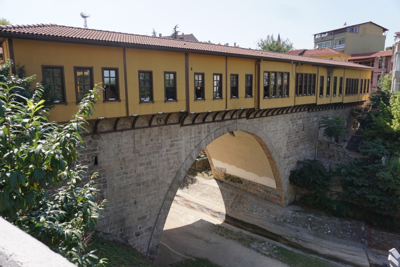
	From the 13th century to the advent of the railway in the early 20th century, Safranbolu was an important caravan station on the main East&ndash;West trade route. The Old Mosque, Old Bath and S&uuml;leyman Pasha Medrese were built in 1322. During its apogee in the 17th century, Safranbolu&#39;s architecture influenced urban development throughout much of the Ottoman Empire.</p></div></div><a href="javascript:void(0);" class="icomosItemAccordion"><div class="text">Wooden Hypostyle Mosques of Medieval Anatolia</div></a><div class="icomosAccordionText"><div class="left"><div class="imageList"><a href="DMLT_Resimler/0368270001723559080.jpg" data-fancybox="gallery21" data-caption="Wooden Hypostyle Mosques of Medieval Anatolia"><img src="DMLT_Resimler/0368270001723559080.jpg" /></a></div><div class="description"><span>1&#46;Afyonkarahisar Ulu Camii &#58; Ege Bölgesi&#44; Afyonkarahisar&#44; Merkez 2&#46;Ahi Şerefeddin &#40;Arslanhane&#41; Camii &#58; İç Anadolu Bölgesi&#44; Ankara&#44; Altındağ 3&#46;Sivrihisar Ulu Camii &#58; İç Anadolu Bölgesi&#44; Eskişehir&#44; Sivrihisar 4&#46;Mahmut Bey Camii &#58; Karadeniz Bölgesi&#44; Kastamon</span><br /><span>1&#46;Afyonkarahisar Ulu Camii&#58;  30° 31&#8216; 46&#46;471&#8217;&#8217; Doğu 38° 45&#8216; 18&#46;129&#8217;&#8217; Kuzey 2&#46;Ahi Şerefeddin &#40;Arslanhane&#41; Camii&#58; 32° 51&#8216; 55&#46;042&#8217;&#8217;Doğu 39° 56&#8216; 12&#46;681&#8217;&#8217; Kuzey 3&#46;Sivrihisar Ulu Camii&#58; 31° 32&#8216; 14&#46;202&#8217;&#8217; Doğu 39° 27&#8216; 03&#46;559&#8217;&#8217; Kuzey 4&#46;Mahmut Bey Camii&#58; 33° 41&#8216; 17&#46;</span><br /><b>List Date:</b> 2023<br /><b>Criteria:</b> <a data-fancybox data-type="iframe" data-src="Kriterler.php?sira=21&dil=en" href="javascript:;" style="text-decoration:none !important;color:#165e2c !important;outline:none !important;">(ii) (iv)</a><br /><b>Area:</b> 0&#46;61 ha<br /><b>List Number:</b> 1694</div></div><div class="right"><b>&#45;</b><br /><br /><span style="color: rgb(33, 33, 33); font-family: Inter, sans-serif; font-size: 16px;">This serial property is comprised of five hypostyle mosques built in Anatolia between the late 13th and mid-14th centuries, each located in a different province of present-day T&uuml;rkiye. The unusual structural system of the mosques combines an exterior building envelope built of masonry with multiple rows of wooden interior columns (&ldquo;hypostyle&rdquo;) that support a flat wooden ceiling and the roof. These mosques are known for the skilful woodcarving and handiwork used in their structures, architectural fittings, and furnishings.</span></div></div><a href="javascript:void(0);" class="icomosItemAccordion"><div class="text">Gordion</div></a><div class="icomosAccordionText"><div class="left"><div class="imageList"><a href="DMLT_Resimler/0284443001723558611.jpg" data-fancybox="gallery20" data-caption="Gordion"><img src="DMLT_Resimler/0284443001723558611.jpg" /></a></div><div class="description"><span>Ankara</span><br /><span>31° 59&#8217; 10 Doğu 39°38&#8217;36 Kuzey</span><br /><b>List Date:</b> 2023<br /><b>Criteria:</b> <a data-fancybox data-type="iframe" data-src="Kriterler.php?sira=20&dil=en" href="javascript:;" style="text-decoration:none !important;color:#165e2c !important;outline:none !important;">(iii)</a><br /><b>Area:</b> 1&#44;064 ha<br /><b>List Number:</b> 1669</div></div><div class="right"><b>&#45;</b><br /><br /><p style="box-sizing: border-box; margin-top: 0px; margin-bottom: 1rem; color: rgb(33, 33, 33); font-family: Inter, sans-serif; font-size: 16px;">
	<span style="box-sizing: border-box;">The archaeological site of Gordion ranks as one of the most important historical centres in the ancient Near East. Gordion lies approximately ninety kilometres south-west of Ankara in central T&uuml;rkiye, at the intersection of the great empires to the east (Assyrians, Babylonians, Hittites) and the west (Greeks, Romans). Consequently, it occupied a strategic position on nearly all trade routes that linked the Aegean and Mediterranean seas with the Near East. Gordion is an outstanding archaeological site for understanding the Phrygian civilisation and its achievements. The buildings of its Early Phrygian citadel, and the burial mounds of the city&rsquo;s rulers, constitute the exceptional exemplars of monumental architecture in the Iron Age Near East.</span></p>
<p style="box-sizing: border-box; margin-top: 0px; margin-bottom: 1rem; color: rgb(33, 33, 33); font-family: Inter, sans-serif; font-size: 16px;">
	<span style="box-sizing: border-box;">The entrance to the Phrygian citadel features the best-preserved Iron Age (10th-8th centuries BCE) fortified gate complex that has yet been discovered, with stone masonry still preserved to a height of ten metres. The elite buildings within the citadel feature the earliest known coloured floor mosaics. The citadel&rsquo;s industrial quarter, or Terrace Complex, was dedicated to large-scale food preparation and the production of textiles. With a length of over a hundred metres, the complex is without parallel in the ancient world. The roofing systems of the citadel&rsquo;s buildings featured timber beams over ten metres in length with no internal supports, which is a daring, unparalleled feat of engineering for the period. The large concentration of monumental tumuli in the vicinity of Gordion creates an exceptional landscape of power, different from any other site in the Near East. The largest of the tumuli, the &ldquo;Midas Mound&rdquo; (Tumulus MM), rises to a height of fifty-three metres and the burial chamber within is the oldest known standing wooden building in the world (ca. 740 BCE), and inside it was found the best-preserved wooden furniture known from antiquity.</span></p>
<p style="box-sizing: border-box; margin-top: 0px; margin-bottom: 1rem; color: rgb(33, 33, 33); font-family: Inter, sans-serif; font-size: 16px;">
	<span style="box-sizing: border-box; font-weight: bolder;">Criterion (iii):</span><span style="box-sizing: border-box;">&nbsp;Gordion was the political and cultural centre of ancient Phrygia and today it represents the best surviving testimony to Phrygian civilisation, an Iron Age civilisation which developed in Anatolia and excelled in timber construction, woodcarving and metalwork.</span></p>
<p style="box-sizing: border-box; margin-top: 0px; margin-bottom: 1rem; color: rgb(33, 33, 33); font-family: Inter, sans-serif; font-size: 16px;">
	<span style="box-sizing: border-box;"><span style="box-sizing: border-box; font-weight: bolder;">Integrity</span></span></p>
<p style="box-sizing: border-box; margin-top: 0px; margin-bottom: 1rem; color: rgb(33, 33, 33); font-family: Inter, sans-serif; font-size: 16px;">
	<span style="box-sizing: border-box;">The property fully includes all the attributes that re&#64258;ect its Outstanding Universal Value and is large enough for the context of these to be properly appreciated and understood. A long-term conservation programme under implementation ensures that an appropriate state of conservation is progressively achieved for all excavated areas. The tumuli and the unexcavated areas are overall in good condition, although smaller tumuli suffer from the effects of deep-ploughing. Measures are being envisaged to prevent their further erosion.</span></p>
<p style="box-sizing: border-box; margin-top: 0px; margin-bottom: 1rem; color: rgb(33, 33, 33); font-family: Inter, sans-serif; font-size: 16px;">
	<span style="box-sizing: border-box; font-weight: bolder;">Authenticity</span></p>
<p style="box-sizing: border-box; margin-top: 0px; margin-bottom: 1rem; color: rgb(33, 33, 33); font-family: Inter, sans-serif; font-size: 16px;">
	<span style="box-sizing: border-box;">The level of authenticity of all attributes of the property is high. Seventy years of excavation and research have revealed a remarkable quality, quantity, and variety of archaeological remains, with high levels of preservation. There has been in situ consolidation work on parts of the structures on the Citadel Mound. The substantial amount of data recovered from the archaeological excavations has ensured that the archaeological remains subject to stabilisation/consolidation work retain a high level of authenticity in terms of material and design. All stabilisation work has been based on complete and detailed documentation.</span></p>
<p style="box-sizing: border-box; margin-top: 0px; margin-bottom: 1rem; color: rgb(33, 33, 33); font-family: Inter, sans-serif; font-size: 16px;">
	<span style="box-sizing: border-box; font-weight: bolder;">Protection and management requirements</span></p>
<p style="box-sizing: border-box; margin-top: 0px; margin-bottom: 1rem; color: rgb(33, 33, 33); font-family: Inter, sans-serif; font-size: 16px;">
	<span style="box-sizing: border-box;">The property has the highest level of site designation, having been designated as a 1st and 3rd degree archaeological conservation area by the Decision No.1096, 16/02/1990 of the Ankara Regional Council for Conservation of Cultural and Natural Properties. In addition, the status of 3rd degree archaeological conservation area designation ensures that the immediate setting of the Citadel Mound at the west and north peripheries is protected from adverse development. This is also protected and managed within the framework of the Protection of Cultural and Natural Properties Law n.&nbsp;2863/1983.</span></p>
<p style="box-sizing: border-box; margin-top: 0px; margin-bottom: 1rem; color: rgb(33, 33, 33); font-family: Inter, sans-serif; font-size: 16px;">
	<span style="box-sizing: border-box;">The buffer zone is protected through national, regional, or local plans and through its designation as agricultural land, subject to provisions of the Soil Protection and Land-Use Law n. 5403/2005. The wider setting is covered by District Rural Settlement Development Plans. A management system and mechanisms are in place and include a management plan: its implementation through a participative approach towards the local community will guarantee its effectiveness.</span></p>
<p style="box-sizing: border-box; margin-top: 0px; margin-bottom: 1rem; color: rgb(33, 33, 33); font-family: Inter, sans-serif; font-size: 16px;">
	<span style="box-sizing: border-box;">Proactive measures to prevent looting and mechanisms to support the farming community vis-&agrave;-vis the necessary restrictions to preserve buried archaeological deposits are key for the long-term sustenance of the integrity and authenticity of the attributes of Gordion&rsquo;s Outstanding Universal Value, as is the preservation of the rural character of its immediate and wider setting.</span></p></div></div><a href="javascript:void(0);" class="icomosItemAccordion"><div class="text">Archaeological Site of Troy</div></a><div class="icomosAccordionText"><div class="left"><div class="imageList"><a href="DMLT_Resimler/0787955001538037545.jpg" data-fancybox="gallery15" data-caption="Archaeological Site of Troy"><img src="DMLT_Resimler/0787955001538037545.jpg" /></a></div><div class="description"><span>Çanakkale</span><br /><span>N39 57 23&#46;184 E26 14 20&#46;4</span><br /><b>List Date:</b> 1998<br /><b>Criteria:</b> <a data-fancybox data-type="iframe" data-src="Kriterler.php?sira=15&dil=en" href="javascript:;" style="text-decoration:none !important;color:#165e2c !important;outline:none !important;">(ii)(iii)(vi)</a><br /><b>Area:</b> 158 ha<br /><b>List Number:</b> 849</div></div><div class="right"><style type="text/css">
p.p1 {margin: 0.0px 0.0px 0.0px 0.0px; font: 12.0px 'Helvetica Neue'; color: #454545}</style>
<p class="p1">
	Troy, with its 4,000 years of history, is one of the most famous archaeological sites in the world. The first excavations at the site were undertaken by the famous archaeologist Heinrich Schliemann in 1870. In scientific terms, its extensive remains are the most significant demonstration of the first contact between the civilizations of Anatolia and the Mediterranean world. Moreover, the siege of Troy by Spartan and Achaean warriors from Greece in the 13th or 12th century B.C., immortalized by Homer in the Iliad, has inspired great creative artists throughout the world ever since.</p>
<br /></div></div><a href="javascript:void(0);" class="icomosItemAccordion"><div class="text">Selimiye Mosque and its Social Complex</div></a><div class="icomosAccordionText"><div class="left"><div class="imageList"><a href="DMLT_Resimler/0658185001538037386.jpg" data-fancybox="gallery14" data-caption="Selimiye Mosque and its Social Complex"><img src="DMLT_Resimler/0658185001538037386.jpg" /></a><a href="DMLT_Resimler/0766122001538037407.jpg" data-fancybox="gallery14" data-caption="Selimiye Mosque and its Social Complex"><img src="DMLT_Resimler/0766122001538037407.jpg" /></a><a href="DMLT_Resimler/0254582001538037422.jpg" data-fancybox="gallery14" data-caption="Selimiye Mosque and its Social Complex"><img src="DMLT_Resimler/0254582001538037422.jpg" /></a></div><div class="description"><span>Edirne</span><br /><span>N41 40 40 E26 33 34</span><br /><b>List Date:</b> 2011<br /><b>Criteria:</b> <a data-fancybox data-type="iframe" data-src="Kriterler.php?sira=14&dil=en" href="javascript:;" style="text-decoration:none !important;color:#165e2c !important;outline:none !important;">(i), (iv)</a><br /><b>Area:</b> 2&#46;50 ha<br /><b>List Number:</b> 1366</div></div><div class="right"><style type="text/css">
p.p1 {margin: 0.0px 0.0px 0.0px 0.0px; font: 12.0px 'Helvetica Neue'; color: #454545}</style>
<p class="p1">
	The square Mosque with its single great dome and four slender minarets, dominates the skyline of the former Ottoman capital of Edirne. Sinan, the most famous of Ottoman architects in the 16th century, considered the complex, which includes madrasas (Islamic schools), a covered market, clock house, outer courtyard and library, to be his best work. The interior decoration using Iznik tiles from the peak period of their production testifies to an art form that remains unsurpassed in this material. The complex is considered to be the most harmonious expression ever achieved of the Ottoman k&uuml;lliye, a group of buildings constructed around a mosque and managed as a single institution.</p>
<br /></div></div><a href="javascript:void(0);" class="icomosItemAccordion"><div class="text">Neolithic Site of Çatalhöyük</div></a><div class="icomosAccordionText"><div class="left"><div class="imageList"><a href="DMLT_Resimler/0811810001538037234.jpg" data-fancybox="gallery13" data-caption="Neolithic Site of Çatalhöyük"><img src="DMLT_Resimler/0811810001538037234.jpg" /></a><a href="DMLT_Resimler/0798746001538037254.jpg" data-fancybox="gallery13" data-caption="Neolithic Site of Çatalhöyük"><img src="DMLT_Resimler/0798746001538037254.jpg" /></a><a href="DMLT_Resimler/0387182001538037266.jpg" data-fancybox="gallery13" data-caption="Neolithic Site of Çatalhöyük"><img src="DMLT_Resimler/0387182001538037266.jpg" /></a></div><div class="description"><span>Konya</span><br /><span>N37 40 0 E32 49 41</span><br /><b>List Date:</b> 2012<br /><b>Criteria:</b> <a data-fancybox data-type="iframe" data-src="Kriterler.php?sira=13&dil=en" href="javascript:;" style="text-decoration:none !important;color:#165e2c !important;outline:none !important;">(iii), (iv)</a><br /><b>Area:</b> 37 ha<br /><b>List Number:</b> 1405</div></div><div class="right"><style type="text/css">
p.p1 {margin: 0.0px 0.0px 0.0px 0.0px; font: 12.0px 'Helvetica Neue'; color: #454545}</style>
<p class="p1">
	Two hills form the 37 ha site on the Southern Anatolian Plateau. The taller eastern mound contains eighteen levels of Neolithic occupation between 7400 bc and 6200 bc, including wall paintings, reliefs, sculptures and other symbolic and artistic features. Together they testify to the evolution of social organization and cultural practices as humans adapted to a sedentary life. The western mound shows the evolution of cultural practices in the Chalcolithic period, from 6200 bc to 5200 bc. &Ccedil;atalh&ouml;y&uuml;k provides important evidence of the transition from settled villages to urban agglomeration, which was maintained in the same location for over 2,000 years. It features a unique streetless settlement of houses clustered back to back with roof access into the buildings.
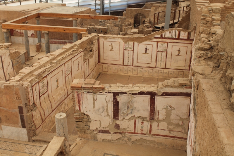
</p>
<br /></div></div><a href="javascript:void(0);" class="icomosItemAccordion"><div class="text">Pergamon and its Multi&#45;Layered Cultural Landscape</div></a><div class="icomosAccordionText"><div class="left"><div class="imageList"><a href="DMLT_Resimler/0295715001538036795.jpg" data-fancybox="gallery11" data-caption="Pergamon and its Multi&#45;Layered Cultural Landscape"><img src="DMLT_Resimler/0295715001538036795.jpg" /></a><a href="DMLT_Resimler/0841569001538036998.jpg" data-fancybox="gallery11" data-caption="Pergamon and its Multi&#45;Layered Cultural Landscape"><img src="DMLT_Resimler/0841569001538036998.jpg" /></a><a href="DMLT_Resimler/0279595001538037007.jpg" data-fancybox="gallery11" data-caption="Pergamon and its Multi&#45;Layered Cultural Landscape"><img src="DMLT_Resimler/0279595001538037007.jpg" /></a><a href="DMLT_Resimler/0358790001538037027.jpg" data-fancybox="gallery11" data-caption="Pergamon and its Multi&#45;Layered Cultural Landscape"><img src="DMLT_Resimler/0358790001538037027.jpg" /></a><a href="DMLT_Resimler/0167892001545680839.jpg" data-fancybox="gallery11" data-caption="Pergamon and its Multi&#45;Layered Cultural Landscape"><img src="DMLT_Resimler/0167892001545680839.jpg" /></a><a href="DMLT_Resimler/0531982001545680925.jpg" data-fancybox="gallery11" data-caption="Pergamon and its Multi&#45;Layered Cultural Landscape"><img src="DMLT_Resimler/0531982001545680925.jpg" /></a></div><div class="description"><span>İzmir</span><br /><span>N39 7 33 E27 10 48</span><br /><b>List Date:</b> 2014<br /><b>Criteria:</b> <a data-fancybox data-type="iframe" data-src="Kriterler.php?sira=11&dil=en" href="javascript:;" style="text-decoration:none !important;color:#165e2c !important;outline:none !important;">(i), (ii), (iii), (iv), (vi)</a><br /><b>Area:</b> 333 ha<br /><b>List Number:</b> 1457</div></div><div class="right"><style type="text/css">
p.p1 {margin: 0.0px 0.0px 0.0px 0.0px; text-align: justify; font: 12.0px 'Helvetica Neue'; color: #454545}</style>
<p class="p1">
	This site rises high above the Bakir&ccedil;ay Plain in Turkey&rsquo;s Aegean region. The acropolis of Pergamon was the capital of the Hellenistic Attalid dynasty, a major centre of learning in the ancient world. Monumental temples, theatres, stoa or porticoes, gymnasium, altar and library were set into the sloping terrain surrounded by an extensive city wall. The rock-cut Kybele Sanctuary lies to the north-west on another hill visually linked to the acropolis. Later the city became capital of the Roman province of Asia known for its Asclepieion healing centre. The acropolis crowns a landscape containing burial mounds and remains of the Roman, Byzantine and Ottoman empires in and around the modern town of Bergama on the lower slopes.</p>
<p class="p1">
	<style type="text/css">
p.p1 {margin: 0.0px 0.0px 0.0px 0.0px; font: 12.0px 'Helvetica Neue'; color: #454545}	</style>
</p>
<p>
	&nbsp;</p></div></div><a href="javascript:void(0);" class="icomosItemAccordion"><div class="text">Bursa and Cumalıkızık&#58; the Birth of the Ottoman Empire</div></a><div class="icomosAccordionText"><div class="left"><div class="imageList"><a href="DMLT_Resimler/0746525001538036980.jpg" data-fancybox="gallery12" data-caption="Bursa and Cumalıkızık&#58; the Birth of the Ottoman Empire"><img src="DMLT_Resimler/0746525001538036980.jpg" /></a><a href="DMLT_Resimler/0247633001538037090.jpg" data-fancybox="gallery12" data-caption="Bursa and Cumalıkızık&#58; the Birth of the Ottoman Empire"><img src="DMLT_Resimler/0247633001538037090.jpg" /></a><a href="DMLT_Resimler/0238526001538037096.jpg" data-fancybox="gallery12" data-caption="Bursa and Cumalıkızık&#58; the Birth of the Ottoman Empire"><img src="DMLT_Resimler/0238526001538037096.jpg" /></a><a href="DMLT_Resimler/0547500001538037110.jpg" data-fancybox="gallery12" data-caption="Bursa and Cumalıkızık&#58; the Birth of the Ottoman Empire"><img src="DMLT_Resimler/0547500001538037110.jpg" /></a><a href="DMLT_Resimler/0173217001545729640.jpg" data-fancybox="gallery12" data-caption="Bursa and Cumalıkızık&#58; the Birth of the Ottoman Empire"><img src="DMLT_Resimler/0173217001545729640.jpg" /></a><a href="DMLT_Resimler/0013807001545729743.jpg" data-fancybox="gallery12" data-caption="Bursa and Cumalıkızık&#58; the Birth of the Ottoman Empire"><img src="DMLT_Resimler/0013807001545729743.jpg" /></a><a href="DMLT_Resimler/0255728001545729755.jpg" data-fancybox="gallery12" data-caption="Bursa and Cumalıkızık&#58; the Birth of the Ottoman Empire"><img src="DMLT_Resimler/0255728001545729755.jpg" /></a></div><div class="description"><span>Bursa</span><br /><span>N40 11 5&#46;03 E29 3 44&#46;41</span><br /><b>List Date:</b> 2014<br /><b>Criteria:</b> <a data-fancybox data-type="iframe" data-src="Kriterler.php?sira=12&dil=en" href="javascript:;" style="text-decoration:none !important;color:#165e2c !important;outline:none !important;">(i), (ii), (iv), (vi)</a><br /><b>Area:</b> 27 ha<br /><b>List Number:</b> 1452</div></div><div class="right"><style type="text/css">
p.p1 {margin: 0.0px 0.0px 0.0px 0.0px; font: 12.0px 'Helvetica Neue'; color: #454545}</style>
<p class="p1">
	This property is a serial nomination of eight component sites in the City of Bursa and the nearby village of Cumalıkızık, in the southern Marmara region. The site illustrates the creation of an urban and rural system establishing the Ottoman Empire in the early 14th century. The property embodies the key functions of the social and economic organization of the new capital which evolved around a civic centre. These include commercial districts of khans, kulliyes (religious institutions) integrating mosques, religious schools, public baths and a kitchen for the poor, as well as the tomb of Orhan Ghazi, founder of the Ottoman dynasty. One component outside the historic centre of Bursa is the village of Cumalıkızık, the only rural village of this system to show the provision of hinterland support for the capital.</p>
<br /></div></div><a href="javascript:void(0);" class="icomosItemAccordion"><div class="text">Diyarbakır Fortress and Hevsel Gardens Cultural Landscape</div></a><div class="icomosAccordionText"><div class="left"><div class="imageList"><a href="DMLT_Resimler/0246804001538036651.jpg" data-fancybox="gallery10" data-caption="Diyarbakır Fortress and Hevsel Gardens Cultural Landscape"><img src="DMLT_Resimler/0246804001538036651.jpg" /></a><a href="DMLT_Resimler/0534203001538036666.jpg" data-fancybox="gallery10" data-caption="Diyarbakır Fortress and Hevsel Gardens Cultural Landscape"><img src="DMLT_Resimler/0534203001538036666.jpg" /></a></div><div class="description"><span>Diyarbakır</span><br /><span>N37 54 11&#46;16 E40 14 21&#46;51</span><br /><b>List Date:</b> 2015<br /><b>Criteria:</b> <a data-fancybox data-type="iframe" data-src="Kriterler.php?sira=10&dil=en" href="javascript:;" style="text-decoration:none !important;color:#165e2c !important;outline:none !important;">(iv)</a><br /><b>Area:</b> 521<br /><b>List Number:</b> 1488</div></div><div class="right"><style type="text/css">
p.p1 {margin: 0.0px 0.0px 0.0px 0.0px; font: 12.0px 'Helvetica Neue'; color: #454545} p.p2 {margin: 0.0px 0.0px 0.0px 0.0px; font: 12.0px 'Helvetica Neue'; color: #454545; min-height: 14.0px}</style>
<p class="p1">
	<span style="color: rgb(0, 0, 0); font-size: 16.6px; background-color: rgb(238, 238, 238);">Located on an escarpment of the Upper Tigris River Basin that is part of the so-called Fertile Crescent, the fortified city of Diyarbakır and the landscape around has been an important centre since the Hellenistic period, through the Roman, Sassanid, Byzantine, Islamic and Ottoman times to the present. The site encompasses the Inner castle, known as İ&ccedil;kale and including the Amida Mound, and the 5.8 km-long city walls of Diyarbakır with their numerous towers, gates, buttresses, and 63 inscriptions. The site also includes the Hevsel Gardens, a green link between the city and the Tigris that supplied the city with food and water, the Anzele water source and the Ten-Eyed Bridge.</span></p></div></div><a href="javascript:void(0);" class="icomosItemAccordion"><div class="text">Ephesus</div></a><div class="icomosAccordionText"><div class="left"><div class="imageList"><a href="DMLT_Resimler/0657024001537858837.jpg" data-fancybox="gallery2" data-caption="Ephesus"><img src="DMLT_Resimler/0657024001537858837.jpg" /></a><a href="DMLT_Resimler/0755114001545681015.jpg" data-fancybox="gallery2" data-caption="Ephesus"><img src="DMLT_Resimler/0755114001545681015.jpg" /></a><a href="DMLT_Resimler/0690302001545681309.jpg" data-fancybox="gallery2" data-caption="Ephesus"><img src="DMLT_Resimler/0690302001545681309.jpg" /></a></div><div class="description"><span>İZMİR</span><br /><span>N37 55 45 E27 21 34</span><br /><b>List Date:</b> 2015<br /><b>Criteria:</b> <a data-fancybox data-type="iframe" data-src="Kriterler.php?sira=2&dil=en" href="javascript:;" style="text-decoration:none !important;color:#165e2c !important;outline:none !important;">(iii), (iv), (vi)</a><br /><b>Area:</b> 663 ha<br /><b>List Number:</b> 1018</div></div><div class="right"><b>&#45;</b><br /><br /><span style="color: rgb(0, 0, 0); font-size: 16.6px; background-color: rgb(238, 238, 238);">Located within what was once the estuary of the River Kaystros, Ephesus comprises successive Hellenistic and Roman settlements founded on new locations, which followed the coastline as it retreated westward. Excavations have revealed grand monuments of the Roman Imperial period including the Library of Celsus and the Great Theatre. Little remains of the famous Temple of Artemis, one of the &ldquo;Seven Wonders of the World,&rdquo; which drew pilgrims from all around the Mediterranean. Since the 5</span><span style="margin: 0px; padding: 0px; vertical-align: top; font-size: 0.8em; color: rgb(0, 0, 0); background-color: rgb(238, 238, 238);">th</span><span style="color: rgb(0, 0, 0); font-size: 16.6px; background-color: rgb(238, 238, 238);">&nbsp;century, the House of the Virgin Mary, a domed cruciform chapel seven kilometres from Ephesus, became a major place of Christian pilgrimage. The Ancient City of Ephesus is an outstanding example of a Roman port city, with sea channel and harbour basin.</span></div></div><a href="javascript:void(0);" class="icomosItemAccordion"><div class="text">Archaeological Site of Ani</div></a><div class="icomosAccordionText"><div class="left"><div class="imageList"><a href="DMLT_Resimler/0699376001538036461.jpg" data-fancybox="gallery9" data-caption="Archaeological Site of Ani"><img src="DMLT_Resimler/0699376001538036461.jpg" /></a><a href="DMLT_Resimler/0325922001545681371.jpg" data-fancybox="gallery9" data-caption="Archaeological Site of Ani"><img src="DMLT_Resimler/0325922001545681371.jpg" /></a><a href="DMLT_Resimler/0189367001545681548.jpg" data-fancybox="gallery9" data-caption="Archaeological Site of Ani"><img src="DMLT_Resimler/0189367001545681548.jpg" /></a></div><div class="description"><span>Kars</span><br /><span>N40 30 0 E43 34 0</span><br /><b>List Date:</b> 2016<br /><b>Criteria:</b> <a data-fancybox data-type="iframe" data-src="Kriterler.php?sira=9&dil=en" href="javascript:;" style="text-decoration:none !important;color:#165e2c !important;outline:none !important;">(ii), (iii), (iv)</a><br /><b>Area:</b> 251 ha<br /><b>List Number:</b> 1518</div></div><div class="right"><p class="p1" color:="" helvetica="" style="margin: 0px; font-variant-numeric: normal; font-variant-east-asian: normal; font-stretch: normal; line-height: normal; font-family: ">
	<span style="color: rgb(0, 0, 0); font-size: 16.6px; background-color: rgb(238, 238, 238);">This site is located on a secluded plateau of northeast Turkey overlooking a ravine that forms a natural border with Armenia. This medieval city combines residential, religious and military structures, characteristic of a medieval urbanism built up over the centuries by Christian and then Muslim dynasties. The city flourished in the 10th and 11th centuries CE when it became the capital of the medieval Armenian kingdom of the Bagratides and profited from control of one branch of the Silk Road. Later, under Byzantine, Seljuk and Georgian sovereignty, it maintained its status as an important crossroads for merchant caravans. The Mongol invasion and a devastating earthquake in 1319 marked the beginning of the city&rsquo;s decline. The site presents a comprehensive overview of the evolution of medieval architecture through examples of almost all the different architectural innovations of the region between the 7th and 13th centuries CE.</span></p></div></div><a href="javascript:void(0);" class="icomosItemAccordion"><div class="text">Aphrodisias</div></a><div class="icomosAccordionText"><div class="left"><div class="imageList"><a href="DMLT_Resimler/0003775001537859661.jpg" data-fancybox="gallery8" data-caption="Aphrodisias"><img src="DMLT_Resimler/0003775001537859661.jpg" /></a><a href="DMLT_Resimler/0289375001545681637.jpg" data-fancybox="gallery8" data-caption="Aphrodisias"><img src="DMLT_Resimler/0289375001545681637.jpg" /></a><a href="DMLT_Resimler/0970383001545681716.jpg" data-fancybox="gallery8" data-caption="Aphrodisias"><img src="DMLT_Resimler/0970383001545681716.jpg" /></a></div><div class="description"><span>Aydın</span><br /><span>N37 42 30 E28 43 25</span><br /><b>List Date:</b> 2017<br /><b>Criteria:</b> <a data-fancybox data-type="iframe" data-src="Kriterler.php?sira=8&dil=en" href="javascript:;" style="text-decoration:none !important;color:#165e2c !important;outline:none !important;">(ii), (iii), (iv), (vi)</a><br /><b>Area:</b> 152 ha<br /><b>List Number:</b> 1519</div></div><div class="right"><font face="Arial, Verdana, sans-serif"><span style="font-size: 16.6px; background-color: rgb(238, 238, 238);">Located in southwestern Turkey, in the upper valley of the Morsynus River, the site consists of two components: the archaeological site of Aphrodisias and the marble quarries northeast of the city. The temple of Aphrodite dates from the 3rd century BC and the city was built one century later. The wealth of Aphrodisias came from the marble quarries and the art produced by its sculptors. The city streets are arranged around several large civic structures, which include temples, a theatre, an agora and two bath complexes.</span></font></div></div><a href="javascript:void(0);" class="icomosItemAccordion"><div class="text">Gobekli Tepe</div></a><div class="icomosAccordionText"><div class="left"><div class="imageList"><a href="DMLT_Resimler/0272802001537858596.jpg" data-fancybox="gallery5" data-caption="Gobekli Tepe"><img src="DMLT_Resimler/0272802001537858596.jpg" /></a></div><div class="description"><span>Şanlıurfa</span><br /><span>N37 13 23&#46;671 E38 55 20&#46;51</span><br /><b>List Date:</b> 2018<br /><b>Criteria:</b> <a data-fancybox data-type="iframe" data-src="Kriterler.php?sira=5&dil=en" href="javascript:;" style="text-decoration:none !important;color:#165e2c !important;outline:none !important;">(i), (ii), (iv)</a><br /><b>Area:</b> 126 ha<br /><b>List Number:</b> 1572</div></div><div class="right"><b>&#45;</b><br /><br /><span style="font-size: 16.6px; background-color: rgb(238, 238, 238);">Located in the Germuş mountains of south-eastern Anatolia, this property presents monumental circular and rectangular megalithic structures, interpreted as enclosures, which were erected by hunter-gatherers in the Pre-Pottery Neolithic age between 9,600 and 8,200 BCE. These monuments were probably used in connection with rituals, mostly likely of a funerary nature. Distinctive T-shaped pillars are carved with images of wild animals, providing insight into the way of life and beliefs of people living in Upper Mesopotamia about 11,500 years ago.</span></div></div><a href="javascript:void(0);" class="icomosItemAccordion"><div class="text">Arslantepe Mound</div></a><div class="icomosAccordionText"><div class="left"><div class="imageList"><a href="DMLT_Resimler/0680559001627464871.jpg" data-fancybox="gallery19" data-caption="Arslantepe Mound"><img src="DMLT_Resimler/0680559001627464871.jpg" /></a></div><div class="description"><span>Malatya</span><br /><span>N38 22 55&#46;5 E38 21 39&#46;7</span><br /><b>List Date:</b> 2021<br /><b>Criteria:</b> <a data-fancybox data-type="iframe" data-src="Kriterler.php?sira=19&dil=en" href="javascript:;" style="text-decoration:none !important;color:#165e2c !important;outline:none !important;">(iii)</a><br /><b>Area:</b> 4&#46;85 ha<br /><b>List Number:</b> 1622</div></div><div class="right"><b>Arslantepe Mound is a 30&#45;metre&#45;tall archaeological tell located in the Malatya plain&#44; 12 km south&#45;west of the Euphrates River&#46; Archaeological evidence from the site testifies to its occupation from at least the 6th millennium BCE up until the late Roman period&#46; The earliest layers of the Early Uruk period are characterized by adobe houses from the first half of the 4th millennium BCE&#46;</b><br /><br />The most prominent and flourishing period of the site was in the Late Chalcolithic period, during which the so-called palace complex was constructed. Considerable evidence also testifies to the Early Bronze Age period, most prominently identified by the Royal Tomb complex. The archaeological stratigraphy then extends to the Paleo-Assyrian and Hittite periods, including Neo-Hittite levels. The site illustrates the processes which led to the emergence of a State society in the Near East and a sophisticated bureaucratic system that predates writing. Exceptional metal objects and weapons have been excavated at the site, among them the earliest swords so far known in the world, which suggests the beginning of forms of organized combat as the prerogative of an elite, who exhibited them as instruments of their new political power.&nbsp;</div></div> 
					<div class="icomosItemAccordionTitle" style="margin-top:40px;">Cultural and Natural Heritage</div>
					
					<a href="javascript:void(0);" class="icomosItemAccordion"><div class="text">Göreme National Park and the Rock Sites of Cappadocia</div></a><div class="icomosAccordionText"><div class="left"><div class="imageList"><a href="DMLT_Resimler/0860069001537859198.jpg" data-fancybox="gallery6" data-caption="Göreme National Park and the Rock Sites of Cappadocia"><img src="DMLT_Resimler/0860069001537859198.jpg" /></a><a href="DMLT_Resimler/0642021001537859213.jpg" data-fancybox="gallery6" data-caption="Göreme National Park and the Rock Sites of Cappadocia"><img src="DMLT_Resimler/0642021001537859213.jpg" /></a><a href="DMLT_Resimler/0303857001537859222.jpg" data-fancybox="gallery6" data-caption="Göreme National Park and the Rock Sites of Cappadocia"><img src="DMLT_Resimler/0303857001537859222.jpg" /></a><a href="DMLT_Resimler/0403609001537859233.jpg" data-fancybox="gallery6" data-caption="Göreme National Park and the Rock Sites of Cappadocia"><img src="DMLT_Resimler/0403609001537859233.jpg" /></a></div><div class="description"><span>Nevşehir &#45; Kayseri</span><br /><span>N38 40 0&#46;012 E34 51 0</span><br /><b>List Date:</b> 1985<br /><b>Criteria:</b> <a data-fancybox data-type="iframe" data-src="Kriterler.php?sira=6&dil=en" href="javascript:;" style="text-decoration:none !important;color:#165e2c !important;outline:none !important;">(i), (iii), (v), (vii)</a><br /><b>Area:</b> 9&#44;884 ha<br /><b>List Number:</b> 357</div></div><div class="right"><style type="text/css">
p.p1 {margin: 0.0px 0.0px 0.0px 0.0px; font: 12.0px 'Helvetica Neue'; color: #454545}</style>
<p class="p1">
	In a spectacular landscape, entirely sculpted by erosion, the G&ouml;reme valley and its surroundings contain rock-hewn sanctuaries that provide unique evidence of Byzantine art in the post-Iconoclastic period. Dwellings, troglodyte villages and underground towns &ndash; the remains of a traditional human habitat dating back to the 4th century &ndash; can also be seen there.</p>
<br /></div></div><a href="javascript:void(0);" class="icomosItemAccordion"><div class="text">Hierapolis&#45;Pamukkale</div></a><div class="icomosAccordionText"><div class="left"><div class="imageList"><a href="DMLT_Resimler/0793997001537859409.jpg" data-fancybox="gallery7" data-caption="Hierapolis&#45;Pamukkale"><img src="DMLT_Resimler/0793997001537859409.jpg" /></a></div><div class="description"><span>Denizli</span><br /><span>N37 55 26&#46;004 E29 7 23&#46;988</span><br /><b>List Date:</b> 1988<br /><b>Criteria:</b> <a data-fancybox data-type="iframe" data-src="Kriterler.php?sira=7&dil=en" href="javascript:;" style="text-decoration:none !important;color:#165e2c !important;outline:none !important;">(iii), (iv), (vii)</a><br /><b>Area:</b> 1&#44;077 ha<br /><b>List Number:</b> 485</div></div><div class="right"><style type="text/css">
p.p1 {margin: 0.0px 0.0px 0.0px 0.0px; font: 12.0px 'Helvetica Neue'; color: #454545}</style>
<p class="p1">
	Deriving from springs in a cliff almost 200 m high overlooking the plain, calcite-laden waters have created at Pamukkale (Cotton Palace) an unreal landscape, made up of mineral forests, petrified waterfalls and a series of terraced basins. At the end of the 2nd century B.C. the dynasty of the Attalids, the kings of Pergamon, established the thermal spa of Hierapolis. The ruins of the baths, temples and other Greek monuments can be seen at the site.</p>
<br /></div></div>					
				</div>
			</div>
		</div>
		<div class="container-fluid" style="padding:30px 0; background:#f5f5f5;">
			<div class="container">
				<div class="col-xs-12 nopadding">
					<div class="icomosSocialMedia">
						<a href="https://twitter.com/ICOMOSTURKEY" target="_blank"><img src="assets/images/twitter.png" border="0" /></a>
						<a href="https://www.facebook.com/pages/Icomos-Turkey/132398016910423" target="_blank"><img src="assets/images/facebook.png" border="0" /></a>
						<a href="https://www.instagram.com/explore/tags/icomost%C3%BCrkiye/" target="_blank"><img src="assets/images/instagram.png" border="0" style="margin-right:0;" /></a>
					</div>
					<div class="icomosCopyright">
						Copyright © 2018 ICOMOS Turkey. All rights reserved					</div>
					<div class="icomosSearch">
						<input type="text" name="icomosSearch" id="icomosSearch" placeholder="Search" style="float:left;display:inline;width:calc(100% - 65px);padding:0 15px;height:40px;background:#fff;border:1px solid #cfcfcf;outline:none;color:#666;font-size:12px;text-align:left;border-radius:0;box-shadow:0;-webkit-appearance: none;">
						<div style="float:left;display:inline;margin-left:5px;width:60px;height:40px;background:#156822 url(assets/images/search.png) no-repeat center center;cursor:pointer;"></div>
					</div>
				</div>
			</div>
		</div>
		<div class="container-fluid" style="padding:60px 0; background:#156822;">
			<div class="container">
				<div class="col-xs-12 nopadding icomosFooter">
					<img src="assets/images/bottom1.png" border="0" class="bottom1Img" />
					<div class="bottom1Text">
						<strong>Address</strong><br />İstanbul Teknik Üniversitesi Mimarlık Fakültesi<br />Taşkışla, Oda No:105, Harbiye<br />  Şişli 34367 İstanbul  TÜRKiYE
					</div>
					<img src="assets/images/bottom2.png" border="0" class="bottom2Img" />
					<div class="bottom2Text">
						<strong>Email</strong><br />icomosturkiye@gmail.com<br />icomos@icomos.org.tr
					</div>
					<img src="assets/images/bottom3.png" border="0" class="bottom3Img" />
					<div class="bottom3Text">
						<strong>Telephone</strong><br />+ 90 212 383 26 30
					</div>
				</div>
			</div>
		</div>
	</body>
</html>